Image 1. A view of the native Tongan forest, undisturbed by human interferences of agriculture or nonnative tree plantations. These areas are becoming exceedingly rare as the native forests are fragmented with the expansion of plantations and agriculture.

Image 2. An example of a non-native palm tree plantation, which are planted for lumber and timber economic activities as they are faster growing and more lucrative than the native vegetation. However, the native forests are essential in maintaining biodiversity and the ecosystem services they provide for the native Tongans.

Image 3. Another palm tree plantation which demonstrates the obvious loss of biomass and diversity that results from the conversion of native forests to these monoculture plantations. The native forest can be seen in the background, and it is clearly evident how much more dense and biodiverse the native forests are.

Image 4. The nonnative palms can be seen emerging above the canopy of the native trees on the beach. These invasive trees are better at water use and thus outcompete the native Tongan trees.

Image 5. An expanse of native vegetation, which demonstrates the diversity of these trees and the closed canopy, home to countless other plants and animal species. When these are clear cut for conversion to tree plantations or agriculture, indeterminable amounts of biodiversity are threatened, as well as the release of many gigatonnes of carbon dioxide into the atmosphere, as these native forests serve as massive carbon sinks.

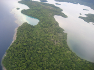
Image 6. Two small islands of Tonga that remain covered by native forests because they are uninhabited by humans.

Image 7. In contrast, this island which is clearly used as a harbor, has been invaded by nonnative trees, which can be seen emerging through the shorter native vegetation in the center. Because of their better adaptations at water and nutrient uptake, the native forests will quickly be outcompeted by the invaders, taking with them much biodiversity.

Image 8. Another example of palm trees emerging through the native forest.

Image 9: A close up view of palm trees emerging through a native forest.
Google Earth Satellite Imagery:
Of the 5 divisions of Tonga, the small island of ‘Eau remains mostly covered by native moist forests. As can be seen by the green line, a significant part of the island has been protected as a national park:


This is in contrast with the main island of Tongatapu which has been mostly developed and not much native expanses of forest remains due to rapid economic development as a commercial and transport hub.

A zoomed in view of the vegetation which has now been replaced by agriculture and plantations, and crisscrossed by roads.


The small island of Oua is in an in-between stage, with large expanses of native vegetation remaining but also clear evidence of human disturbance and replacement with agriculture and nonnative tree plantations.

There are similar results on the island of Vavau, which shows undisturbed native vegetation on the rugged coastline but land cover change by humans inland:

A zoomed in view of the native vegetation:


A Google Earth image of Tau, which shows the same results as the map above: nonnative palm trees surrounded by the remaining native moist forest.
Sources
http://www.roperld.com/tonga.htm
http://www.spc.int/lrd/pafpnetwiki/index.php?title=Tonga
http://worldfocus.org/blog/2009/11/05/tongas-traditional-ways-threatened-by-climate-change/8199/
http://www.amextravelplanning.com/destinations/tonga
http://www.metrolic.com/travel-guides-tonga-156446/
http://www.travelpod.com/travel-photo/carolandowen/1/1241651220/tonga-beach.jpg/tpod.html
All satellite images were created using Google Earth

The outline of Eau National Park:

A close up view of the native vegetation and canopy:

This small island to the southwest of Eau is also covered by native vegetation, which is due to the fact that it remains uninhabited. With the looming threat of population growth and the limited resource of land, areas such as these threaten to also be converted to agriculture and nonnative plantations.

This is in contrast with the main island of Tongatapu which has been mostly developed and not much native expanses of forest remains due to rapid economic development as a commercial and transport hub.

A zoomed in view of the vegetation which has now been replaced by agriculture and plantations, and crisscrossed by roads.


The small island of Oua is in an in-between stage, with large expanses of native vegetation remaining but also clear evidence of human disturbance and replacement with agriculture and nonnative tree plantations.

There are similar results on the island of Vavau, which shows undisturbed native vegetation on the rugged coastline but land cover change by humans inland:

A zoomed in view of the native vegetation:


Image 10. A map of the island of Tau which shows native forest cover along the perimeter of the island, and various forms of nonnative, human-caused land cover inland.

A Google Earth image of Tau, which shows the same results as the map above: nonnative palm trees surrounded by the remaining native moist forest.
Sources
http://www.roperld.com/tonga.htm
http://www.spc.int/lrd/pafpnetwiki/index.php?title=Tonga
http://worldfocus.org/blog/2009/11/05/tongas-traditional-ways-threatened-by-climate-change/8199/
http://www.amextravelplanning.com/destinations/tonga
http://www.metrolic.com/travel-guides-tonga-156446/
http://www.travelpod.com/travel-photo/carolandowen/1/1241651220/tonga-beach.jpg/tpod.html
All satellite images were created using Google Earth